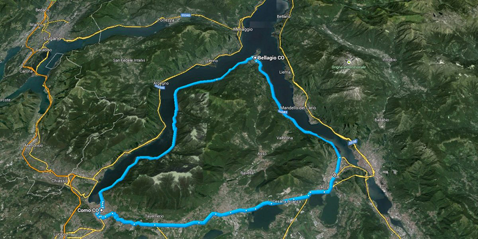
The most “Norwegian” of the great Alpine lakes offers many reasons of interest. Narrow and deep like a Scandinavian fjord, the Lario extended for several kilometers from Valtellina to Bellagio, where it opens into the two famous branches of Como and Lecco.
There are many paths that allow you to climb the slopes of the mountains overlooking the deep blue waters of the lake. The intense blue hides the maximum depth in Italy for a lake: 416 meters!
BOFFALORA REFUGE
From Pigra, 880 meters above sea level (from Argegno you can arrive by funicular), follow the road to the Boffalora refuge. The road climbs (wide views over Lake Como) up to Alpe di Colonno. From there, passing along the northern slope of the Cima della Duaria, you reach the Boffalora alp where the refuge of the same name stands. Beyond the refuge, continue for a hundred meters up to a crossroads where you take the road (partly unpaved) for Ponna. From Ponna (870 m asl) you go down to Laino and then to Claino con Osteno (270 m asl) from where you skirt the shores of Lake Lugano. To avoid the main road from Porlezza to Menaggio, at the height of Crotto Galbiga, turn right passing in front of the oratory of San Maurizio (11th century). At the end of the road, turn left until you reach a bridge where you turn right following the Cuccio stream. At the next intersection, turn left and, after crossing the bridge, turn right onto the cycle path that leads to the Casa della Riserva del Lago di Piano (276 meters above sea level). Follow the shore of the lake crossing a wooden bridge and pass two campsites.Twenty meters after the entrance to the Ranocchio campsite, take the small road on the right which immediately becomes a dirt road that passes behind the campsite. You cross a ford in the middle of the fields, follow a dry river bed and take a dirt road back to Bene Lario (377 masl).

Once on the asphalt, turn left and at the crossroads take via Binadone to the main road (Girandola ed Uniti).
Four kilometers separate from Menaggio and another fifteen kilometers separate Menaggio from Argegno.
Medium-high difficulty itinerary.

MONTE BISBINO
The challenging climb to Monte Bisbino starts in Cernobbio, a town near Como, which can be easily reached along the road that runs close to the Lario. From Cernobbio the climb is heavy: in just 13 km, in fact, you can overcome an altitude difference of 850 meters. The road is paved.
For those who have already conquered Mount Bisbino or for those who just love the dirt road, the climb offers an alternative: once past Ca ‘Bassi, instead of reaching the summit of Bisbino, you can turn downhill towards the Bugone refuge and then up and down to the Binate refuge.
High difficulty itinerary.
TRIANGOLO LARIANO
From Brunate (715 masl), arrival of the funicular that climbs in a few minutes from Como, continue left to immediately turn right and pass the church. Go up to San Maurizio (906 meters above sea level) where, once you reach the square, you pass to the left of the façade of the Church and take the mule track that comes out in piazzale Cao. You pass by the Cao refuge, Baita Carla, Baita Bondella and the Boletto Fabrizio refreshment point to reach Capanna San Pietro (1116 masl). From here, follow the “Senteé di Foo”, a path of beech trees, which passes under the northern slope of Mount Bollettone to arrive at Bocchetta di Lemna (1167 masl). From the pass you reach the Bocchetta di Palanzo. It flanks the west side of Mount Palanzone to reach the Riella refuge (1275 masl), beyond it there is a fountain. Arriving at Cippo Marelli you pass the extensive meadows of the Preaola up to the Bocchetta di Caglio. Reached an isolated group of beech trees at the beginning of the Braga di Cavallo, the difficult descent begins to Colma di Caglio and then to Colma del Piano (1124 masl), also known as di Sormano. From this location you can get off at Asso, where the railway station is located. The ridge of the Larian Triangle continues as far as Bellagio. Continuing the ride, you leave the ridge for a short stretch and instead of going down to Pian del Tivano you continue on a dirt road that climbs to Alpe Spessola (1237 masl).
A steep climb leads to Alpe di Terra Biotta (1436 masl, maximum altitude): it is difficult to descend to Alpe del Borgo (1180 masl) and then more easily towards Borgo San Primo.

After the ex-colony of Bonomelli, take a narrow path on the right as you exit the pine forest. Once you arrive at the Pau pasture, take a driveway up to Rovenza (724 masl) and other steep descents through Brogno, Begola and Perlo up to Guggiate, a hamlet of Bellagio.
The entire itinerary, 90% on dirt roads, measures 30 kilometers.


